Geological and topographical maps, their interpretation and use, a handbook for the geologist and civil engineer (1911)
Dwerryhouse, Arthur Richard, 1867- · London, E. Arnold · leaf 121
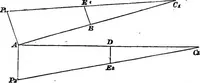
required directions, in which the dip will be 20°. (e) Given the depth at which a stratum, say a seamof coal, is encountered in three boreholes, whichare not in a straight line, and whose position andheight above the sea are known, to determine thedip and strike, and also the depth at which the bed… … particulars are known, and D the position of theproposed boring:— Boring A. Height above the sea . 550 feet. Depth of seam .... 2650 „ Boring B. Height above the sea . 725 feet. Depth of seam .... 4225 „ Boring G. Height above the sea . 450 feet. Depth of seam .... 4450 „ Site D. Height above the…
Cartography · Geology · Topographical drawing
Internet Archive · Cornell University Library · Public Domain Mark 1.0. Free to use for anything.